Category:Guillaume Brouscon
Jump to navigation
Jump to search
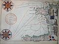
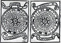
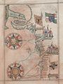
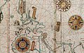
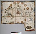
Guillaume Brouscon was a French mapmaker of the Dieppe school in the 16th century. He was from the port of Le Conquet, near Brest. He published his Brouscon's Almanachs in 1546, which were used for their informations on tides by English, French and Breton sailors. They allowed to known the direction of tidal currents, and to calculate tide level depending on the phase of the moon
French cartographer | |||||
| Upload media | |||||
| Name in native language |
| ||||
|---|---|---|---|---|---|
| Date of birth | 16th century (statement with Gregorian date earlier than 1584) Le Conquet | ||||
| Date of death | 16th century | ||||
| Country of citizenship | |||||
| Occupation | |||||
| |||||
Pages in category "Guillaume Brouscon"
This category contains only the following page.
Media in category "Guillaume Brouscon"
The following 16 files are in this category, out of 16 total.
-
 039 Portulan de Guillaume Brouscon 1548.JPG 3,072 × 2,304; 2.96 MB
-

-
-
 Brouscon France Nord 1543.jpg 1,500 × 2,000; 452 KB
-
 Brouscon France Ouest 1548.jpg 1,233 × 1,651; 738 KB
-

-

-

-

-
-

-

-
-

-
 Map-043a.jpg 560 × 600; 87 KB
-


._HM_46._PORTOLAN_ATLAS_and_NAUTICAL_ALMANAC._France,_1543_(cropped).jpg)
._HM_46._PORTOLAN_ATLAS_and_NAUTICAL_ALMANAC._France,_1543_(cropped).jpg)
._HM_46._PORTOLAN_ATLAS_and_NAUTICAL_ALMANAC._France,_1543_(cropped).jpg)

._HM_46._PORTOLAN_ATLAS_and_NAUTICAL_ALMANAC._France,_1543.A.jpg)
._HM_46._PORTOLAN_ATLAS_and_NAUTICAL_ALMANAC._France,_1543.B.jpg)
._HM_46._PORTOLAN_ATLAS_and_NAUTICAL_ALMANAC._France,_1543.C.jpg)
._HM_46._PORTOLAN_ATLAS_and_NAUTICAL_ALMANAC._France,_1543.jpg)
._HM_46._PORTOLAN_ATLAS_and_NAUTICAL_ALMANAC._France,_1543_(cropped).jpg)

._HM_46._PORTOLAN_ATLAS_and_NAUTICAL_ALMANAC._France,_1543_(cropped).jpg)